Saspamco Paddling Trail
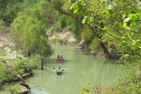
Just minutes away from the bustling City of San Antonio, the abundant trees along this trail offer shade and diverse wildlife and birdwatching opportunities. Paddlers can enjoy a variety of water types including quiet pools and several small riffles.
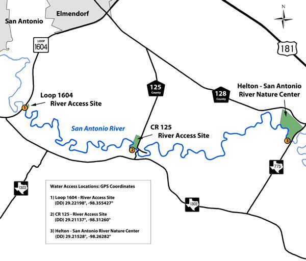
Trail Access
Loop 1604 River Access Site
- Type:
- Put In
- GPS Coordinates:
- 29.2220, -98.3554
6890 S. Loop 1604 E.
Located 3.7 mi. east of IH 37 or 4.6 mi. southwest of US 181 on S. Loop 1604 East.
CR 125 River Access Site
- Type:
- Access Point
- GPS Coordinates:
- 29.2114, -98.3126
Alternate Mid-point Access Site. 1239 Wilson County Rd 125; located 0.3 miles northeast of FM 1303.
Helton – San Antonio River Nature Center
- Type:
- Take Out
- GPS Coordinates:
- 29.2153, -98.2628
15662 FM 775; located 1.2 miles southwest of US 181.
Navigating the Trail
Trail Length: 5.6 - 12 miles (depending on route taken)
Float Times:2-8 hours (depending on route taken, time spent on river, water level, flow rate, and wind speed)
Trail Description
Route lengths:
- Loop 1604 River Access Site to Helton – San Antonio River Nature Center: 12.1 miles (4-8 hours)
- Loop 1604 River Access Site to CR 125 River Access Site: 5.63 miles (2-4 hours)
- CR 125 River Access Site to Helton – San Antonio River Nature Center: 6.43 miles (2-4 hours)
IMPORTANT NOTE WHEN PLANNING PARKING AND SHUTTLE VEHICLES: Driving distances between access sites via FM 1303 are: A) put-in to take-out = 8.5 mi.; B) put-in to alternate mid-point = 3.9 mi.; and C) alternate mid-point to take-out = 5.2 mi.
Note: Starting the weekend of February 4-5, 2012, the three river access sties will be open daylight hours on Saturdays and Sundays only. We will update this site once longer hours/days are available for this trail.
Although there are no man-made obstructions on this reach, there may be snags to avoid, especially when water levels are low. Heavy rains and high water can create dangerous conditions. The Lower San Antonio River is a natural river that is unrestrained by flood control dams or other man-made structures. As such, the Lower San Antonio River is readily influenced by rainfall runoff that may create temporary high flows and undesirable water quality conditions. Flow and water quality information is available to paddlers on the SARA website.
Private Property
Respect private property by not trespassing or littering and keeping noise levels down. This river is classified as navigable, which permits public use of the streambed and, if necessary, the banks to portage any hazard. Any other use of private river banks without permission of the landowner can be considered trespassing. Under Texas Penal Code (§30.05), criminal trespass occurs when one enters property after receiving notice not to enter. Notice includes verbal notice, a fence, sign(s), purple paint on posts or trees, or the visible presence of crops grown for human consumption.
Trail Map
Things to Do and See
Fishing
This section of the river supports several sunfish, bass, and catfish species. Small lures such as jigs, plastic worms, spinner baits and light-line are recommended.
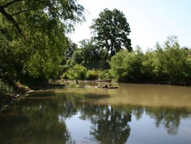
Wildlife and Ecology
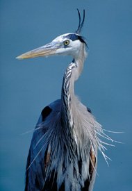
The heavily wooded riparian corridor along this stretch of the San Antonio River provides habitat for an active, diverse bird population. Birds spotted here include kingfishers, herons, hawks, phoebes, and a variety of migratory songbirds in the spring and early fall. Trees such as boxelder, cypress, cottonwood, pecan, and green ash provide shade for visitors and shelter for birds and other wildlife; to include deer, armadillo, raccoons, and squirrels. Visitors may also see feral hogs and occasionally livestock watering in the river.
Rentals and Shuttles
Texas Pack & Paddle
Rent kayaks, paddles, and life jackets; take kayak instruction classes, or reserve guided tours and group tours. All services are by appointment only. For more information call (210)494-4200.
Partnership
This trail was made possible through a partnership between Texas Parks and Wildlife Department and the San Antonio River Authority.