Goliad Paddling Trail
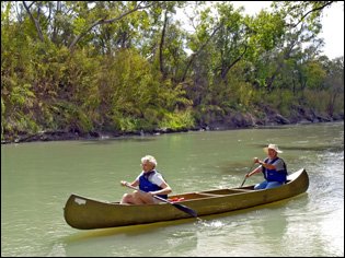
Enjoy quiet pools and several small riffles on the first inland paddling trail to include a State Park. Located on the San Antonio River near the town of Goliad, this 6.6-mile river trail can be floated in two and a half to four hours.
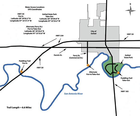
Trail Access
Highway 59
- Type:
- Put In
- GPS Coordinates:
- 28.6525, -97.4314
Northwest of where Highway 59 crosses the San Antonio River. From the intersection of Hwy 59 and Hwy 183, travel west towards Beeville 2.8 miles. The access point is located to the right under the bridge.
Ferry Street
- Type:
- Access Point
- GPS Coordinates:
- 28.6610, -97.3927
The Ferry Street access site can be used as an optional put-in or take-out site, however, parking is limited. The Ferry Street access site is located approximately 5 river miles down from the put-in site.
The Ferry Street access site can be accessed from the intersection of Hwy 59 and Hwy 183 by traveling west towards Beeville to the next stop light. Turn left onto Commercial Street, proceed .3 miles. Commercial Street becomes Ferry Street at the end of the paved road. Continue to the turn-around and park vehicles in the grass off of the turn-around.
Goliad State Park
- Type:
- Take Out
- GPS Coordinates:
- 28.6527, -97.3817
To get to Goliad State Park, travel 1/4 mile south of Goliad on US Highway 183. Stop at the park headquarters to pay entrance fee and ask directions to the Paddling Trail take-out point within the park.
Navigating the Trail
Trail Description and Landmarks
Trail Length: ~6.6 miles (from put-in to the Goliad State Park access site)
Float Time: ~2.5 - 4 hours (depending on water levels and flow rates)
Please note: The Ferry Street access site can be used as an optional put-in or take-out site, however, parking is limited. The Ferry Street access site is located approximately 5 river miles down from the put-in site.
A variety of water types including quiet pools and several small riffles are present. Although there are no man-made obstructions on this reach, there may be snags to avoid, especially when water levels are low. Heavy rains and high water can create dangerous conditions. The Lower San Antonio River is a natural river that is unrestrained by flood control dams or other man made structures. As such, the Lower San Antonio River is readily influenced by rainfall runoff that may create temporary high flows and undesirable water quality conditions. Flow and water quality information is available to paddlers on the SARA web site www.sara-tx.org
Private Property
Respect private property by not trespassing or littering and keeping noise levels down. This river is classified as navigable, which permits public use of the streambed and, if necessary, the banks to portage any hazard. Any other use of private river banks without permission of the landowner can be considered trespassing. Under Texas Penal Code (§30.05), criminal trespass occurs when one enters property after receiving notice not to enter. Notice includes verbal notice, a fence, sign(s), purple paint on posts or trees, or the visible presence of crops grown for human consumption.
Trail Map
Things to Do and See
Fishing
This section of the river supports numerous sunfish, bass, and catfish. Small lures such as jigs, plastic worms, spinner baits and light-line are recommended.
Wildlife and Ecology
The luxuriant gallery woodlands of the San Antonio River floodplain contrast sharply with the adjacent brushland. The riparian corridor of the San Antonio River supports a great diversity of plant and animal life along the river and beyond the banks. Birdlife along the trail is especially varied, due to proximity of diverse habitats and to the mild regional climate. Birds spotted here include herons, kingfishers, hawks, phoebes, turkeys. Native cypress, oak, and pecan trees grow along the river. Common wildlife encountered include deer, armadillo, and squirrels. It is not unusual to see livestock watering in the river. There is a designated wildlife viewing area at the State Park.
Partnership
This trail was made possible through a partnership between Texas Parks and Wildlife Department, the San Antonio River Authority, and the Canoe Trail Goliad Committee. See www.canoetrailgoliad.com for a full list of participating partners.